Transportaion information : http://eng.ipohang.org/home/eng/travelers_Info/transportation/
Restaurant information :
Korean Restaurant : http://eng.ipohang.org/home/eng/travelers_Info/food/korean/
Western Restaurant : http://eng.ipohang.org/home/eng/travelers_Info/food/western/page.wscms
Japanese Restaurant : http://eng.ipohang.org/home/eng/travelers_Info/food/japanese/page.wscms
Special Dishes : http://eng.ipohang.org/home/eng/travelers_Info/food/special/page.wscms
Accomodation :
Condominium : http://eng.ipohang.org/home/eng/travelers_Info/accommodation/condominium/page.wscms
Hotel : http://eng.ipohang.org/home/eng/travelers_Info/accommodation/hotel/
Motel : http://eng.ipohang.org/home/eng/travelers_Info/accommodation/motel/page.wscms
Pension : http://eng.ipohang.org/home/eng/travelers_Info/accommodation/pension/page.wscms
Shopping : http://eng.ipohang.org/home/eng/travelers_Info/shopping/page.wscms
Emergency Contact : http://eng.ipohang.org/home/eng/travelers_Info/emergency/page.wscms
2010년 11월 29일 월요일
Seaside drive & mountain hiking course
Seashore drive course

Recommend a good course for enjoying the beautiful nature and culture of Pohang while driving by the coast.
- Course : Mt. Bihaksan → Mt. Naeyeonsan → Wolpo Beach → Chilpo Beach → Northern Beach → Jukdo market → POSCO → Homigot → Yeongil Janggi-eup castle
Mt. Naeyeon Hiking Course

Mt. Naeyeonsan is at the south of the Taebaek Mountains facing the East Sea . Since it is not a steep mountain even children can easily climb the mountain. While enjoying the charm of Bogyeongsa Temple which has a long history, and the beautiful waterfalls and the thick forest you will find yourself at the summit of the mountain.
- Schedule: One-day
- Course : Bogyeongsa Temple → Ssangsaeng Waterfall → Moonsuam → Summit( Hyangrobong ) → Bogyeongsa Temple
Introduction of Pohang
- History :
- Silla Dynasty : Toehwa-hyeon, Jidap-hyeon, Geunoji-hyeon, Haeah-hyeon
- Goryeo Dynasty: Re-titled to Heunghae-gun, Janggi-hyeon, Yeongil-hyeon, Cheongha-hyeon
- 1896.08.04 : Four counties, Heunghae, Cheongha, Yeonil, and Janggi were established due to the practice of 13-Do system
- 1914.03.01 : Four counties unified as Yeongil-gun (18 myeons)
- 1931.04.01 : Pohang-myeon promoted to Pohang-eup (1 eup, 17 myeons)
- 1934.04.01 : Jukbuk.Juknam-myeon unified as Jukjang-myeon, Janggi. Bongsan-myeon unified as Jihaeng-myeon (1 eup, 15 myeons)
- 1938.10.01 : Hyeongsan-myeon incorporated into Pohang-eup (1 eup, 14 myeons)
- 1942.10.01 : Changju-myeon promoted to Guryongpo-eup (2 eups, 13 myeons)
- 1949.08.15 : Pohang-eup promoted to Pohang-si (1 si, 1 eup, 13 myeons, 1 branch office)
- 1956.07.08 : Heunghae, Gokgang-myeon incorporated into Uichang-myeon (1 si, 1 eup, 12 myeons)
- 1957.10.29 : Abolition of Daljeon-myeon, incorporated into Heunghae/Yeonil (1 si, 1 eup, 11 myeons)
- 1967.03.01 : Establishment of Gibuk branch office of Gigye-myeon
- 1973.07.01 : Uichang-myeon promoted to Uichang-eup (1 si, 2 eups, 10 myeons, 3 branch offices)
- 1980.12.01 : Yeonil, Ocheon-myeon promoted to eups (1 si, 4 eups, 8 myeons, 3 branch offices)
- 1982.09.01 : Separation of Haedo 1/2 dong, Sangdae 1/2 dong
- 1986.04.01 : Daebo, Gibuk branch office promoted to myeon (1 si, 4 eups, 10 myeons, 1 branch office)
- 1995.01.01 : Starts as united Pohang-si (1 si, 2 gus, 4 eups, 10 myeons, 25 dongs, 1 branch office)
- 1998.09.01 : Unification of Gwaso-dong (1 si, 2 gus, 4 eups, 10 myeons, 19 dongs, 1 branch office)
- 2006.12.26 : Moved into the new building in Daejam-dong

- Location:
- East end: Seokbyeong-ri, Guryongpo-dup, Nam-gu (longitude 129° 34' 57" latitude 36° 02' 34")
– Located at the furthest east end of Korean peninsula - West end: Duma-ri, Jukjang-myeon, Buk-gu (longitude 128° 59' 20" latitude 36° 09' 54")
- South end: Duwon-ri, Janggi-myeon, Nam-gu (longitude 129° 30' 26" latitude 35° 50' 07")
- North end: Haok-ri, Jukjang-myeon, Buk-gu (longitude 129° 17' 09" latitude 36° 19' 49")

- Tourist Map of Pohang City
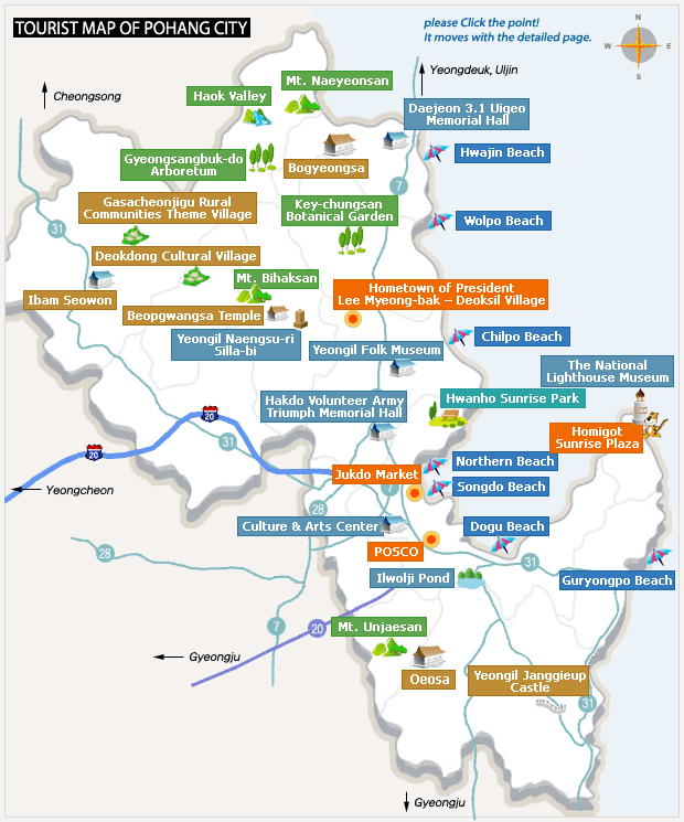
Cited from : http://eng.ipohang.org/ (Pohang City's official web site)
Introduction of our blog
Hi, we are team Baek-Du Mount. from HGU International Business Class.
We will try to provide a tour guide for English Users who visits pohang.
We will be introducing restaurants, pubs, hotels, motels, cafe and so on in English.
Hope all the English users can enjoy their time in Pohang with our blog.
May all the blessings be with you.
We will try to provide a tour guide for English Users who visits pohang.
We will be introducing restaurants, pubs, hotels, motels, cafe and so on in English.
Hope all the English users can enjoy their time in Pohang with our blog.
May all the blessings be with you.
피드 구독하기:
덧글 (Atom)